Soil Test 2: VESS (Visual Evaluation of Soil Structure)
Purpose: to assess soil structure quality, rooting conditions, and porosity by examining soil aggregates and layers, key factors affecting most soil functions.
Material needs:
VESS score chart, digging spade, ruler, tarp / bin bag /tray, camera (on phone)
Time estimated: 20 minutes
Step-by-step instruction:
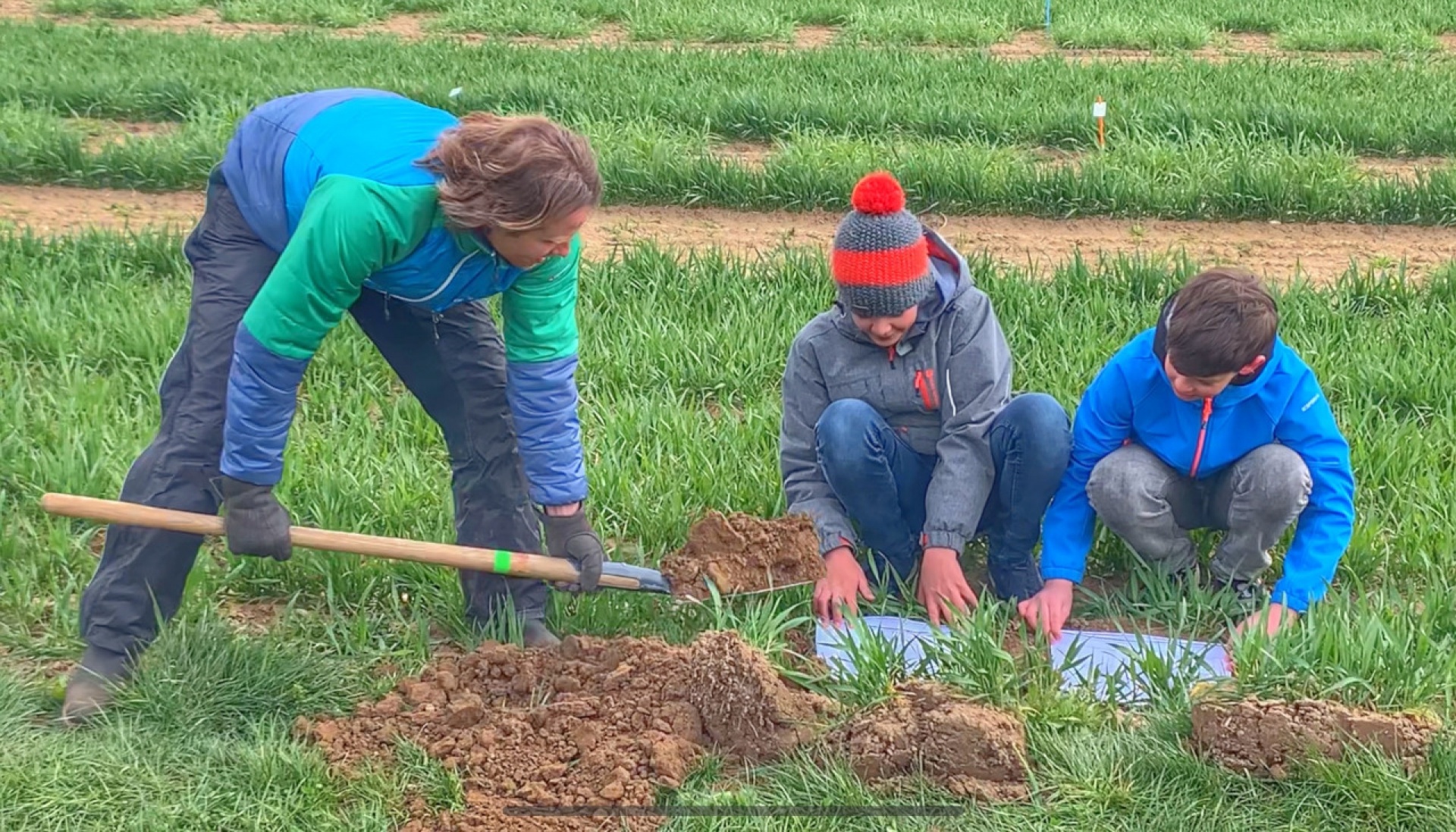
- In case, you did the Soil Test 1, skip directly to point 2. Otherwise, dig a hole of approximately one spade blade’s depth and 20 cm in length. It should be slightly wider than the spade. Try to keep one side of the hole as intact as possible to use it for the spade test. Place the excavated soil on a tarp or in a box to put it back later.
- Excavate an intact block of soil from the intact edge of the hole as follows: Insert the spade vertically on either side of the block to be excavated (one side being the left intact edge from step 1). Alternatively, you can cut slits into the sides of the block with a knife. If the soil is sticky or heavily covered, stabilise the soil surface with your feet when pulling out the spade.
- Then insert the spade vertically into the soil at a distance of approx.10 cm from the hole, parallel to the left-intact edge. Separate the soil tile from the remaining soil volume by pushing the spade slightly forward with your shoulder.
- Use the spade like a lever and carefully lift the sample out of the hole. Stabilise the block with your hand, or use a second spade in front of the soil block and tip the block onto it. Place the block on a plastic tarp.
- Open the block in the middle and push both sides by hand like opening a book to reveal undisturbed areas. Place a meter rule next to the block and take a picture.
- Distinguish soil layers by watching out for changes in colour, soil type, structure, etc. Use your hands to separate the layers into their natural components (the aggregates, see explanation and example images) and note whether you need a lot or a little force to do so. With the form, you will be guided step by step through the description of the layers. Beware, in case you have a clayey or sandy soil (see results from Soil test 1), the possible answers change (in the App, this happens automatically)!
Video tutorial: https://www.youtube.com/watch?v=y5x6Er-L-3E (To open the video, do not click on the link, but copy and paste it into your browser)
Form
- Soil surface description:
Aggregates intact, easily recognisable, permeable surface /
Aggregates partially washed out, surface still rough or uneven /
Aggregates washed out, surface sealed, silted, or compacted, less permeable /
Closed crust, deposited sediments, compacted, very poorly permeable /
- General sample observations:
Rocks / Bad smell / Plow pan / Undecomposed residues / Straw mat / Difficulty digging / Rust stains / Plastic pieces / None
- Number of soil layers: _______
- Depth of layers (cm): _______
Record the following values for each layer separately:
- Aggregate size (mostly): <0.6 cm / <1 cm / 1-2 cm / 2-5 cm / 5-10 cm / >10 cm / a continuous block
- Aggregate form:
All soil types but clayey or sandy: rounded / angular to rounded / angular / sharp-edged
Clayey soil: rounded / angular to rounded / angular or sharp-edged / Very sharp-edged with conchoidal fracture
Sandy soil: No aggregates, only individual grains / rounded / angular to rounded / angular or sharp-edged
- Aggregate porosity:
Porous, many pores / few pores, macropores and cracks possible / dense, no pores or only individual macropores or cracks
- Aggregate stability:
All soil types but clayey or sandy: disintegrates easily, flaky, crumbly, unstable/ little force, stable / great force, hard
Clayey soil: Can be crushed with little force / Can be crushed with more force, but only with the fingers / Can only be crushed with a lot of force of the whole hand
Sandy soil: Disintegrates by itself / Some cohesion, can be crushed with very little force / Can be crushed with little force, stable
- Root description:
Many roots, evenly distributed, finely branched / Few roots, evenly distributed / Unevenly distributed, root-free zones, stunted roots, root clustering around aggregates/ none
- VESS score (see provided VESS score chart): _______
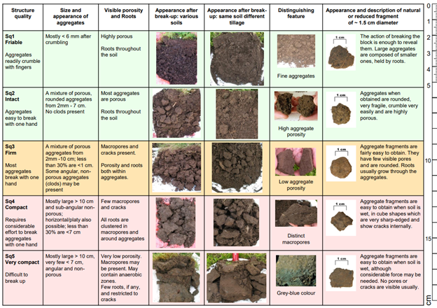
Figure 1 VESS score chart
- References
Burgos, S., Dakhel-Robert, N., Weisskopf, P., Johannes, A., Kellermann, L., Niggli, J., van Geijtenbeek, S., Spuhler, M., Nilles, L., Bünemann-König, E., & Heller, O. (n.d.), Weisskopf, P.. Spatenprobe. Retrieved from https://spatenprobe.ch/
App herunterladen und registrieren
Standort beschreiben
Falls du kein Smartphone besitzt oder aus anderen Gründen lieber mit einem PC teilnimmst, navigiere zur Karte.
Wie hat es denn beim Kabarettisten Simon Enzler funktioniert?